Ocean and Coast: Multibeam Sonar
2/19/13
Comments:
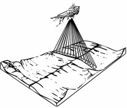
Sonar is a technique that uses sound propagation to navigate, communicate with or detect objects on or under the surface of the water, such as other vessels. Two types of technology share the name "sonar": passive sonar is essentially listening for the sound made by vessels; active sonar is emitting pulses of sounds and listening for echoes. Sonar may be used as a means of acoustic location and of measurement of the echo characteristics of "targets" in the water. Acoustic location in air was used before the introduction of radar. Sonar may also be used in air for robot navigation, and SODAR is used for atmospheric investigations. The term sonar is also used for the equipment used to generate and receive the sound. The acoustic frequencies used in sonar systems vary from very low (infrasonic) to extremely high (ultrasonic). The study of underwater sound is known as underwater acoustics or hydro acoustics.
Sonar is a technique that uses sound propagation to navigate, communicate with or detect objects on or under the surface of the water, such as other vessels. Two types of technology share the name "sonar": passive sonar is essentially listening for the sound made by vessels; active sonar is emitting pulses of sounds and listening for echoes. Sonar may be used as a means of acoustic location and of measurement of the echo characteristics of "targets" in the water. Acoustic location in air was used before the introduction of radar. Sonar may also be used in air for robot navigation, and SODAR is used for atmospheric investigations. The term sonar is also used for the equipment used to generate and receive the sound. The acoustic frequencies used in sonar systems vary from very low (infrasonic) to extremely high (ultrasonic). The study of underwater sound is known as underwater acoustics or hydro acoustics.
Ocean and Coast: CTD and friends
2/20/13
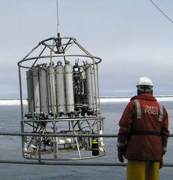
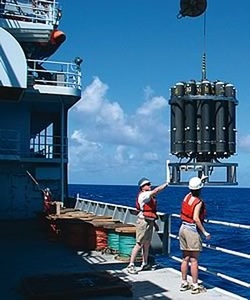
A CTD is a package of electronic devices that measure conductivity, temperature, and depth.
Conductivity is a measure of how well a solution conducts electricity and is directly related to salinity, which is the concentration of salt and other inorganic compounds in seawater. Salinity is one of the most basic measurements used by ocean scientists. When combined with temperature data, salinity measurements can be used to determine seawater density, which is a primary driving force for major ocean currents.
What is it and why do we use it?
A CTD — an acronym for Conductivity, Temperature, and Depth — is the primary tool for determining essential physical properties of sea water. It gives scientists a precise and comprehensive charting of the distribution and variation of water temperature, salinity, and density that helps to understand how the oceans affect life.
How does it work?
The shipboard CTD is made up of a set of small probes attached to a large metal rosette wheel. The rosette is lowered on a cable down to the seafloor, and scientists observe the water properties in real time via a conducting cable connecting the CTD to a computer on the ship. A remotely operated device allows the water bottles to be closed selectively as the instrument ascends. A standard CTD cast, depending on water depth, requires two to five hours to collect a complete set of data.Water sampling is often done at specific depths so scientists can learn the physical properties of the water column are at that particular place and time. Small, low-powered CTD sensors are used on autonomous instruments like the moored profiler, gliders, profiling floats and AUVs .
What platforms are needed?
There can be a host of other accessories and instruments attached to the CTD package. These include Niskin bottles that collect water samples at different depths for measuring chemical properties, Acoustic Doppler Current Profilers (ADCP) that measure the horizontal velocity, and oxygen sensors that measure the dissolved oxygen content of the water.
Advantages and limitations?
Advantages:
Remote sensing
Very accurate
Light weight (CTD only)
Can be used at depths up to several thousand meters
what I found exciting or interesting?
CTDs are often attached to a much larger metal frame called a rosette, which may hold water sampling bottles that are used to collect water at different depths, as well as other instruments that can measure additional physical or chemical properties. Because volcanoes, hydrothermal vents, and some other deep-sea features cause changes to the physical and chemical properties of seawater, ocean explorers can use CTD measurements to detect evidence of these features.
Oceans and Coasts: Aboard a Modern Ship of Discovery
2/20/13
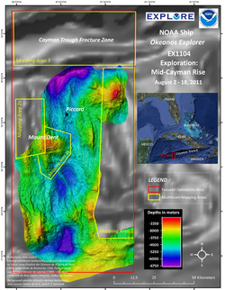
In August 2011, NOAA Ship Okeanos Explorerembarked on an expedition to the deepest part of the Caribbean Sea, where a team of international scientists both at-sea and on shore conducted interdisciplinary investigations of the Mid-Cayman Rise – an ultra-slow spreading center where two plates gradually move apart and upwelling magma creates new crust and the adjacent Cayman Trough. The exploration focused on the oceanic core complexes that appear to dominate construction of the rift valley walls along much of the Mid-Cayman Rise, and the inner wall of the Cayman Trough fracture zone immediately to the north – investigating the geology, marine life, and hydrothermal systems that these areas might host. Over the course of 10 days, they mapped the rift valley walls of the Mid-Cayman Rise and northern wall of the Cayman Trough Fracture zone using the ship’s deep-water multibeam sonar; explored the water column for hydrothermal activity using a CTD rosette, in situ sensors, and shipboard dissolved methane analysis; and conduct detailed seafloor investigations using a two-body remotely operated vehicle (ROV) capable of diving to 4,000m. During the expedition, live video of ongoing operations were streamed to shore where a team of scientists from the U.S. and U.K. join the expedition remotely through the use of “telepresence” technology.
Oceans and Coasts: Tools for Ocean Explorers

Did you know that 95% of Earth’s Ocean is unexplored? That means that humans have not yet seen two-thirds of our planet. A big part of the reason for this is that until recently we really haven’t had the technology to truly see the deep ocean.New discoveries are always exciting to scientists, but information from ocean exploration is important to everyone, because Biodiversity in deep-sea ecosystems includes new species that can provide important drugs and other useful products; Some deep-sea ecosystems include organisms that can be used for human food; Information from deep ocean exploration can help predict earthquakes and tsunamis; and Human benefits from deep ocean systems are being affected by changes in Earth’s climate and atmosphere.
Hydrothermal vent communities and other deepwater chemosynthetic ecosystems are fundamentally different from other biological systems on Earth, and there are plenty of unanswered questions about the individual species and interactions between species found in these communities. Many of these species are new to science, and include primitive living organisms (Archaea) that some scientists believe may have been the first life forms on Earth. Although much remains to be learned, useful products have already been discovered in hydrothermal vent organisms. At present, almost all drugs produced from natural sources come from terrestrial plants, but marine animals produce more drug-like substances than any group of organisms that live on land. Some chemicals from microorganisms found around hydrothermal vents (the exopolysaccharide HE 800 from Vibrio diabolicus) are promising for the treatment of bone injuries and diseases, while similar chemicals may be useful for treating cardiovascular disease. Other examples of useful products include a protein from Thermus thermophylus, which is a microorganism that is adapted to live under extremely high temperature conditions near hydrothermal vents. One of these adaptations is the protein Tth DNA polymerase that can be used to make billions of copies of DNA for scientific studies and crime scene investigations. Another microorganism (genus Thermococcus) produces a type of protein (an enzyme called pullulanase) that can be used to make sweeteners for food additives. Besides being a source of useful natural products, we know that – Earth’s ocean regulates our planet’s climate and atmosphere; – The ocean contains resources that can transform the way we obtain energy for human activities, and eliminate many of the negative consequences that result from the ways we presently obtain energy; The ocean can produce natural disasters that can wreak havoc on coastal communities and entire nations; Humans are now having a measurable impact on ocean life. And yet, we know nearly nothing about 95% of Earth’s ocean. Without exploration, we can’t hope to enjoy the potential benefits the ocean has to offer, nor can we prepare for the problems the ocean may send our way.
Ocean and Coast: Underwater Robots
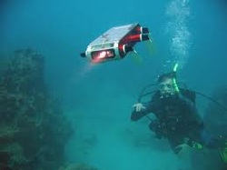
I found interesting that Modern ocean explorers use two main types of underwater robots. Remotely Operated Vehicles and Autonomous Underwater Vehicles. Remotely Operated Vehicles are unoccupied robots linked by a group of cables to an operator aboard a ship, while Autonomous Underwater Vehicles are underwater robots that operate without a pilot or cable to a ship or submersible. Also Because Autonomous Underwater Vehicles operate independently, they are able to cover large areas of the ocean floor, as well as monitor a specific underwater area over a long period of time. Typical Autonomous Underwater Vehicles can follow the contours of underwater mountain ranges, fly around sheer pinnacles, dive into narrow trenches, take photographs, and collect data and samples. This kind of technology is very useful for Oceanography.
